Lowrance Us Lakes: North Central MAX-N+ With and 50 similar items
Envío gratis
103 recent views
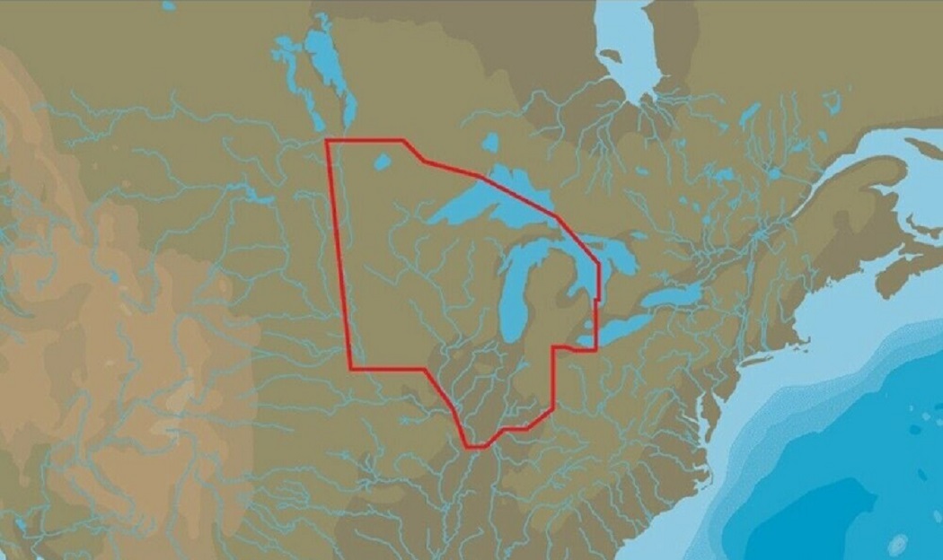
LOWRANCE US LAKES: NORTH CENTRAL MAX-N+ With Marina Info & Port Services
$3,155.53 MXN
(It may be possible to pay only $154.90 instead of $169.90 when you
use your bCredits at checkout)
Sign up and get $5.00 bCredits free to use at checkout and another $5.00 bCredits when you make your first purchase. More info
Share & earn! Sign in, share this or any listing, and you’ll get commission when it sells.
Learn more
View full item details »

Las opciones de envío
Estimado para llegar por Tue, Dec 2nd.
Detalles
Calculado por USPS en MX.
Los buques de
United States

La política de devoluciones
Full refund available within 30 days
Protección de compra
Opciones de pago
PayPal accepted
PayPal Credit accepted
Venmo accepted
PayPal, MasterCard, Visa, Discover, and American Express accepted
Maestro accepted
Amazon Pay accepted
Nuvei accepted
View full item details »
Las opciones de envío
Estimado para llegar por Tue, Dec 2nd.
Detalles
Calculado por USPS en MX.
Los buques de
United States
La política de devoluciones
Full refund available within 30 days
Protección de compra
Opciones de pago
PayPal accepted
PayPal Credit accepted
Venmo accepted
PayPal, MasterCard, Visa, Discover, and American Express accepted
Maestro accepted
Amazon Pay accepted
Nuvei accepted
Rasgos del artículo
| Categoría: | |
|---|---|
| cantidad disponible: |
Sólo uno en stock, para muy pronto |
| Condition: |
New |
| Features: |
Sport Fishing data |
| UPC: |
9420064103560 |
Detalles del anuncio
| Las políticas del vendedor: | |
|---|---|
| Envío de descuento: |
Vendedor paga el envío para este artículo. |
| Publicado en venta: |
Más de una semana |
| Artículo número: |
893556124 |
Descripción del Artículo
GVO Marine Electronics:
We provide reliable, safe online shopping 24 hours a day, 7 days a week throughout the U.S. and the world. We are strongly committed to providing our customers with top quality merchandise and world class service.
Model 84300
M-NA-Y072-MS
When you choose C-MAP you can count on accurate, up-to-date charts from official sources worldwide, advanced features, and C-MAP's commitment to safe navigation. C-MAP MAX-N+ cartography brings the majority of the C-MAP 4D content and many of its features and functions to selected navigation systems, combining accurate, up-to-date global chart data with features designed specifically for avid anglers, cruisers and sailors.
Features:
High-Resolution Bathymetric (HRB) bottom contour/fishing charts to help anglers target fish-holding coastal and offshore structure more effectively
Dynamic Tides Currents predictions that help anglers determine the best times to hit productive rips, shoals, rocks and channels
Aerial photos and worldwide database of Marina Info/Port Services great for cruisers, sailors, and traveling fishermen
Sport Fishing Data for valuable information on wrecks/reefs, including composition, depth, orientation and other details anglers can use to fish more effectively
High-resolution satellite imagery to enhance situational awareness and improve safety
Dynamic Raster Charts for a traditional "paper chart" look with the ability to "pull up" information on important chart objects
Shaded relief vector chart presentation highlights specific depth contours, valuable when cruising or fishing
GVO Marine Electronics: .
Get the item you ordered or get your money back.
Covers your purchase price and original shipping.
|
Why are we showing these items?
Booth
GVO Marine's Booth |
|


, 4-pin Cable (52781) - $472.67 MXN")


-
Refine your browsing experience
We can show you more items that are exactly like the original item, or we can show you items that are similar in spirit. By default we show you a mix.


Este artículo ha sido añadido a su carrito
 LOWRANCE US LAKES: NORTH CENTRAL MAX-N+ With Marina Info & Port Services added to cart.
Único disponible en stock
LOWRANCE US LAKES: NORTH CENTRAL MAX-N+ With Marina Info & Port Services added to cart.
Único disponible en stock
Ver el carro o seguir comprando.
 Por favor, espere mientras termine de agregar este artículo a su carrito.
Get an item reminder
We'll email you a link to your item now and follow up with a single reminder (if you'd like one). That's it! No spam, no hassle.
Already have an account?
Log in and add this item to your wish list.