Rendered at 09:14:23 10/07/25


Sign up and get $5.00 bCredits free to use at checkout and another $5.00 bCredits when you make your first purchase. More info
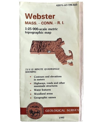
Map Webster Mass CT RI Geological Topographic Survey 1982 24 x 38" DWX6A
$552.31 MXN
Sign up and get $5.00 bCredits free to use at checkout and another $5.00 bCredits when you make your first purchase. More info
Los buques de
United States

Share & earn! Sign in, share this or any listing, and you’ll get commission when it sells.
Learn more

Las opciones de envío
Política de oferta
OBO - El vendedor acepta ofertas en este artículo.
Detalles
La política de devoluciones
Protección de compra
Opciones de pago
PayPal accepted
PayPal Credit accepted
Venmo accepted
PayPal, MasterCard, Visa, Discover, and American Express accepted
Maestro accepted
Amazon Pay accepted
Nuvei accepted
Rasgos del artículo
| Categoría: | |
|---|---|
| cantidad disponible: |
Sólo uno en stock, para muy pronto |
| Condition: |
Unspecified by seller, may be new. |
| Type: |
Topographical Map |
| Original/Reproduction: |
Vintage Original |
| Date Range: |
1980-1989 |
| Year: |
1982 |
| Country/Region: |
United States of America |
| US State: |
Massachusetts |
| Mexican State: |
Nayarit |
| Format: |
Folding Map |
| Printing Technique: |
Lithography |
| Cartographer/Publisher: |
NA |
| City: |
Webster |
| Canadian Province: |
NA |
Detalles del anuncio
| Envío de descuento: |
Pesos de envío de todos los elementos se suman para el ahorro. |
|---|---|
| Publicado en venta: |
September 23 |
| Artículo número: |
1770546890 |
Descripción del Artículo
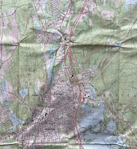
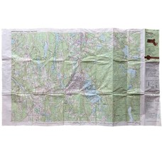
Vintage used condition is typical with light staining, edges roughness....
As seen in pics.
Note: I have thousands of Topographic maps. The folded ones will all have clean maps with no issues outside of what would be regarded as typical wear from light use... this series appears to be NOS. They are creased and wrinkled in areas. All from storage
1:25 000
Approx 24 x 38"
***Disclaimer on old/vintage/antique books/paper and the like:
Some wear from age, use and storage which may or may not include some, none or all of the following: writing/personalized notes on inside covers and title pages(or notes on pages in the case of songbooks and sheet Music), small tears, creasing, etc.... all typical Vintage and antique book wear.
Opposite side may or may not have prints or text which may or may not be related to one shown. Your opinion may differ.
See top of description for any outstanding flaws.
**All items pictured are fully usable and/or functional unless otherwise noted**
Inspect pics closely and ask any questions before buying or offering.
Tons more toys, collectibles, paper, antique, vintage ephemera, maps, engravings, prints, vinyl, vhs, media, books, bags, handmade and more!
Will combine shipping!
Added to your wish list!
- Map Webster Mass CT RI Geological Topographic Survey 1982 24 x 38" DWX6A
- 1 in stock
- Price negotiable
Get an item reminder
We'll email you a link to your item now and follow up with a single reminder (if you'd like one). That's it! No spam, no hassle.
Already have an account?
Log in and add this item to your wish list.