Rendered at 14:34:46 05/24/25


Envío gratis
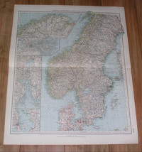
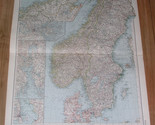
1929 VINTAGE ITALIAN MAP OF SCANDINAVIA / SWEDEN NORWAY DENMARK
Los buques de
Canada


Las opciones de envío
Estimado para llegar por Tue, Jun 17th.
Detalles
$193.38 a través de International Shipping (2 to 3 weeks) a Worldwide
Los buques de
Canada
Política de oferta
OBO - El vendedor acepta ofertas en este artículo.
Detalles
La política de devoluciones
Full refund available within 30 days
Protección de compra
Opciones de pago
PayPal accepted
PayPal Credit accepted
Venmo accepted
PayPal, MasterCard, Visa, Discover, and American Express accepted
Maestro accepted
Amazon Pay accepted
Nuvei accepted
Rasgos del artículo
| Categoría: | |
|---|---|
| cantidad disponible: |
Sólo uno en stock, para muy pronto |
| Condition: |
Acceptable |
| Type: |
Anthropomorphic Map |
| Date Range: |
1920-1929 |
| Year: |
1929 |
| Country/Region: |
Denmark |
| Publication Year: |
1929 |
| Subgenre: |
Scandinavia |
| Language: |
Italian |
| Features: |
Vintage |
| Topic: |
Sweden |
Detalles del anuncio
| Envío de descuento: |
Vendedor paga el envío para este artículo. |
|---|---|
| Publicado en venta: |
May 24 |
| Artículo número: |
1748748305 |
Descripción del Artículo
ORIGIN OF THE MAP: "Atlante Internazionale del Touring Club Italiano", published by Touring Club Italiano, Milan, Italy.
DATE OF ISSUE: 1929.
SIZE: The sheet measures: 24" x 19" (61 x 48 cm).
Most of maps we sell come from ancient atlases that were damaged and beyond repair. The maps have often a canvas or paper binding tape mounted on back along the centerfold. If you have ANY PROBLEM with the purchase, it is essential you CONTACT US BEFORE LEAVING FEEDBACK TO GIVE US THE CHANCE TO RESOLVE IT.
SHIPPED FROM CANADA in secure tubes or bubble mailers. PLEASE NOTE, THAT THE SHIPPING FROM QUEBEC TO THE U.S. TAKES 10 DAYS / WORLD 18 DAYS.
WE COMBINE SHIPPING COST FOR MULTIPLE ITEMS: THE POSTAGE FEE IS CHARGED FOR THE FIRST ITEM ONLY.
Added to your wish list!
- 1929 VINTAGE ITALIAN MAP OF SCANDINAVIA / SWEDEN NORWAY DENMARK
- 1 in stock
- Price negotiable
- Returns/refunds accepted
Get an item reminder
We'll email you a link to your item now and follow up with a single reminder (if you'd like one). That's it! No spam, no hassle.
Already have an account?
Log in and add this item to your wish list.