Rendered at 06:32:37 05/15/25


Envío gratis
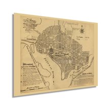
HISTORIX 1792 Vintage Washington DC Map Print - 18x24 Inch Vintage Plan of the C
$774.84 MXN - $1,065.48 MXN
Los buques de
United States


Las opciones de envío
Los buques de 1 business day Detalles
No hay precio de envío se especifica en MX
Los buques de
United States
La política de devoluciones
Full refund available for DOAs
Detalles
Protección de compra
Opciones de pago
PayPal accepted
PayPal Credit accepted
Venmo accepted
PayPal, MasterCard, Visa, Discover, and American Express accepted
Maestro accepted
Amazon Pay accepted
Nuvei accepted
Rasgos del artículo
| Categoría: | |
|---|---|
| cantidad disponible: |
16 En stock |
| Condition: |
New |
| UPC: |
737214975571 |
| Item Name: |
1792 Plan of Washington DC Poster Print |
| Item Type Keyword: |
prints |
| Product Site Launch Date: |
2021-12-29T17:39:33.463Z |
| Unspsc Code: |
60121013 |
| sizes: |
Detalles del anuncio
| Las políticas del vendedor: | |
|---|---|
| Envío de descuento: |
Vendedor paga el envío para este artículo. |
| Publicado en venta: |
May 1 |
| Artículo número: |
1743631415 |
Descripción del Artículo
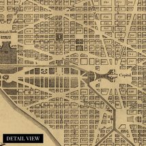
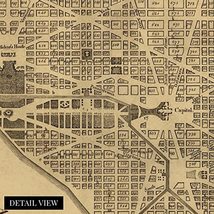
Produced by prolific American surveyor Andrew Ellicott this unique depiction of the plans for the United States capital shows it as the newly independent Colonies began to establish a democratic government and set the models for how the nation would evolve. Due to a provision in the US Constitution, the capital is decreed to be a federal district governed by Congress's exclusive jurisdiction. The Residence Act was signed in 1790 and established the capital on the banks of the Potomac River, and the city was officially established in 1791. During the survey, Ellicott placed stone markers every mile, many of which stand to this day. Congress would hold its first session in Washington DC in 1800.
As perhaps the most iconic place in early American history, the city bears a rich history and distinctive character. As the political center of the United States, Washington DC experienced significant transformation throughout the eighteenth and nineteenth centuries. This original survey of the first established one hundred square miles bears a classic style and signature aesthetic that immediately transports the viewer back in time, creating an indelible bond between the past and present.
The city was invaded by the British during the War of 1812, and Congress, as well as the White House, were gutted and burned. While most buildings were restored relatively quickly, the Capitol Building would not be complete in its current form until 1868. This authentic piece of American cartographical history shows the foundations for this incredibly iconic and remarkable city.
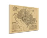
Our museum quality giclee print comes printed with archival ink on premium heavyweight matte paper. Shipped in a sturdy cardboard tube your print will arrive ready to be framed. This eye-catching vintage map reproduction print makes the perfect gift for anyone that loves history and imagery.
Added to your wish list!
- HISTORIX 1792 Vintage Washington DC Map Print - 18x24 Inch Vintage Plan of the C
- 16 in stock
- Available in multiple sizes
- Handling time 1 day.
- Returns/refunds accepted
Get an item reminder
We'll email you a link to your item now and follow up with a single reminder (if you'd like one). That's it! No spam, no hassle.
Already have an account?
Log in and add this item to your wish list.