Rendered at 09:12:41 05/18/25


Envío gratis
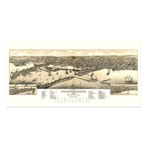
HISTORIX Vintage 1883 Duluth Minnesota Map Poster - 12x24 Inch Old View of Dulut
$740.41 MXN - $1,169.19 MXN
Los buques de
United States


Las opciones de envío
Los buques de 1 business day Detalles
No hay precio de envío se especifica en MX
Los buques de
United States
La política de devoluciones
Full refund available for DOAs
Detalles
Protección de compra
Opciones de pago
PayPal accepted
PayPal Credit accepted
Venmo accepted
PayPal, MasterCard, Visa, Discover, and American Express accepted
Maestro accepted
Amazon Pay accepted
Nuvei accepted
Rasgos del artículo
| Categoría: | |
|---|---|
| cantidad disponible: |
16 En stock |
| Condition: |
New |
| ASIN: |
B0BWVKFSMD |
| Color: |
Natural |
| Bullet Point: | |
| Product Description: | |
| Brand: |
HISTORIX |
| Supplier Declared Dg Hz Regulation: |
not_applicable |
| Item Name: | |
| Item Type Keyword: |
prints |
| sizes: |
Detalles del anuncio
| Las políticas del vendedor: | |
|---|---|
| Envío de descuento: |
Vendedor paga el envío para este artículo. |
| Publicado en venta: |
May 1 |
| Artículo número: |
1743618837 |
Descripción del Artículo
The region first experienced European exploration and settlement beginning in the seventeenth century, with fur trappers looking to supply Europe's demand for beaver fur. These trappers traded with indigenous populations and established small camps that would grow into towns and cities over the course of the eighteenth and nineteenth centuries. Duluth became a critically important city known for its cargo shipping abilities due to its location on Lake Superior. The first official business was established in Duluth in 1808 with the American Fur Company, which German-born immigrant George Astor founded. The region attracted thousands of immigrants looking for economic opportunities in copper and iron ore mining.
Produced and published by Henry Wellge, who was among one of the most prolific mapmakers of the nineteenth and twentieth centuries and is responsible for creating half of all bird's eye perspectives in the Library of Congress, along with five other publishers. Wellge's works bear a distinctive style and classic aesthetic that was designed to attract residents and merchants alike by featuring local businesses and civic features. Panoramic maps were created as marketing materials to attract residents. By the 1880s, Duluth was growing rapidly as advances in transportation allowed access to the North and West following the conclusion of the American Civil War.
Bird's eye perspectives were not limited by the need to be used for navigation and immediately transport the viewer back in time, creating an indelible bond between the past and present. They are distinctive pieces of American cartographical history and culture.
Additional Details
------------------------------
Bullet point: VINTAGE MAP REPRODUCTION: You?ll love this high quality historic reproduction of 1883 Duluth City Minnesota Map Poster. Our museum quality prints are archival grade, which means it will look great and last without fading for over 100 years. Our print to order maps are made in the USA and each map is inspected for quality. This beautiful artwork is a perfect addition to your themed decor. Vintage maps look great in the home, study or office. They make a perfect gift as well.
Product description:
The region first experienced European exploration and settlement beginning in the seventeenth century, with fur trappers looking to supply Europe's demand for beaver fur. These trappers traded with indigenous populations and established small camps that would grow into towns and cities over the course of the eighteenth and nineteenth centuries. Duluth became a critically important city known for its cargo shipping abilities due to its location on Lake Superior. The first official business was established in Duluth in 1808 with the American Fur Company, which German-born immigrant George Astor founded. The region attracted thousands of immigrants looking for economic opportunities in copper and iron ore mining.
Produced and published by Henry Wellge, who was among one of the most prolific mapmakers of the nineteenth and twentieth centuries and is responsible for creating half of all bird's eye perspectives in the Library of Congress, along with five other publishers. Wellge's works bear a distinctive style and classic aesthetic that was designed to attract residents and merchants alike by featuring local businesses and civic features. Panoramic maps were created as marketing materials to attract residents. By the 1880s, Duluth was growing rapidly as advances in transportation allowed access to the North and West following the conclusion of the American Civil War.
Bird's eye perspectives were not limited by the need to be used for navigation and immediately transport the viewer back in time, creating an indelible bond between the past and present. They are distinctive pieces of American cartographical history and culture.
Added to your wish list!
- HISTORIX Vintage 1883 Duluth Minnesota Map Poster - 12x24 Inch Old View of Dulut
- 16 in stock
- Available in multiple sizes
- Handling time 1 day.
- Returns/refunds accepted
Get an item reminder
We'll email you a link to your item now and follow up with a single reminder (if you'd like one). That's it! No spam, no hassle.
Already have an account?
Log in and add this item to your wish list.