Rendered at 19:13:26 05/17/25


Envío gratis
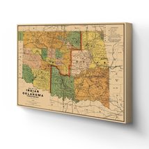
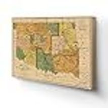
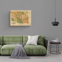
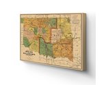
HISTORIX Vintage 1892 Indian & Oklahoma Territory Map Canvas Art - 18x24x1.5 Inc
$4,950.21 MXN - $5,476.44 MXN
Los buques de
United States


Las opciones de envío
Los buques de 1 business day Detalles
No hay precio de envío se especifica en MX
Los buques de
United States
La política de devoluciones
Full refund available for DOAs
Detalles
Protección de compra
Opciones de pago
PayPal accepted
PayPal Credit accepted
Venmo accepted
PayPal, MasterCard, Visa, Discover, and American Express accepted
Maestro accepted
Amazon Pay accepted
Nuvei accepted
Rasgos del artículo
| Categoría: | |
|---|---|
| cantidad disponible: |
16 En stock |
| Condition: |
New |
| ASIN: |
B09695GKWD |
| Item Name: |
1892 Map of the Indian and Oklahoma territories |
| Item Type Keyword: |
artwork |
| Unspsc Code: |
60121013 |
| sizes: |
Detalles del anuncio
| Las políticas del vendedor: | |
|---|---|
| Envío de descuento: |
Vendedor paga el envío para este artículo. |
| Publicado en venta: |
May 1 |
| Artículo número: |
1743601326 |
Descripción del Artículo
Produced by iconic American mapmaker Rand McNally, this depiction of Oklahoma and Indian Territory was published just two years after the state was opened for general settlement. Previously the territory was considered Indian Territory, but two treaties ratified in 1889 caused a land grab allowing local tribes to sell their land to American settlers. The two distinct territories were divided into eastern and western regions, as well as along tribal lines.
This pre-statehood map illustrates the tribes living in this rugged, frontier region and the towns and cities that sprung up alongside them. The Bartlesville oil boom in1897 sparked another influx of miners, and oil drilling became a massive industry for the local economy. The history of Oklahoma’s oilfields is rich and storied with vast fortunes being made overnight and busting just as quickly. The discovery of new oilfields was national news and brought numerous investors seeking riches to the remote territory, and these discoveries were frequent enough to keep the population growing. By 1927 Oklahoma was producing more oil than any other state.
These territories were also leased by major Chicago meatpackers who kept vast herds of cattle to ship north for processing. Oklahoma achieved statehood in 1907, but the 1890s were a transformative and challenging time in the region and are when its reputation as a rough and tumble frontier was well earned. The distinctive aesthetic of Rand McNally maps is immediately recognizable and transports the viewer back in time to vast cattle ranches and oil derricks.
Our ready-to-hang canvas wall art prints are made in the USA using the highest quality materials with professional craftsmanship. This beautiful artwork is a perfect addition to your themed decor. Historic prints look great in the home, study or office. They also make an unforgettable gift.
Added to your wish list!
- HISTORIX Vintage 1892 Indian & Oklahoma Territory Map Canvas Art - 18x24x1.5 Inc
- 16 in stock
- Available in multiple sizes
- Handling time 1 day.
- Returns/refunds accepted
Get an item reminder
We'll email you a link to your item now and follow up with a single reminder (if you'd like one). That's it! No spam, no hassle.
Already have an account?
Log in and add this item to your wish list.