Rendered at 06:58:21 05/15/25


Envío gratis
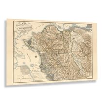
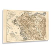
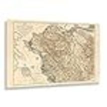
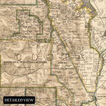
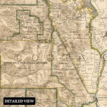
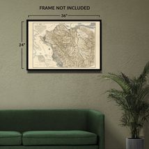
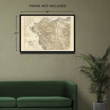
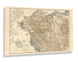
HISTORIX Vintage 1894 Alameda & Contra Costa Map Print - 24x36 Inch Old Map of A
$1,162.36 MXN
Los buques de
United States


Las opciones de envío
Los buques de 1 business day Detalles
No hay precio de envío se especifica en MX
Los buques de
United States
La política de devoluciones
Full refund available for DOAs
Detalles
Protección de compra
Opciones de pago
PayPal accepted
PayPal Credit accepted
Venmo accepted
PayPal, MasterCard, Visa, Discover, and American Express accepted
Maestro accepted
Amazon Pay accepted
Nuvei accepted
Rasgos del artículo
| Categoría: | |
|---|---|
| cantidad disponible: |
8 En stock |
| Condition: |
New |
| MPN: |
ENMAP06922436 |
| UPC: |
705514892133 |
| EAN: |
0705514892133 |
| Paint Type: |
Watercolor |
| color: |
Natural |
| manufacturer: |
HISTORIX |
| Externally Assigned Product Identifier: |
0705514892133 |
| Item Shape: |
Rectangular |
| Bullet Point: | |
| Product Description: | |
| Brand: |
HISTORIX |
| Unspsc Code: |
55101500 |
| orientation: |
Landscape |
| Paper Finish: |
matte |
| Item Name: | |
| Item Type Keyword: |
wall-maps |
| size: |
36L" x 24W" |
| Mounting Type: |
Wall Mount |
| Part Number: |
ENMAP06922436 |
| style: |
Classic |
| Wall Art Form: |
poster |
| Room Type: |
Office |
| Target Gender: |
unisex |
Detalles del anuncio
| Las políticas del vendedor: | |
|---|---|
| Envío de descuento: |
Vendedor paga el envío para este artículo. |
| Publicado en venta: |
Más de una semana |
| Artículo número: |
1735828327 |
Descripción del Artículo
Alameda and Contra Costa Counties have been essential areas in California's Northern Coast for centuries as the regions developed with bustling ports. This map was produced in a period of significant growth and prosperity, which the region had enjoyed since the middle of the nineteenth century when vast gold reserves were discovered in the Sierra Nevada Mountains, bringing considerable wealth to the cities as a banking hub on the West Coast. During the nineteenth century, San Francisco rivaled Los Angeles, Seattle, and Portland, Oregon, as a trading port for goods being imported to the United States from Asia and exporting American-made goods to foreign markets.
As the nation approached the turn of the century, the Bay Area, along with the rest of the country, was being transformed in the years of the Industrial Revolution and a period of peace following the conclusion of the American Civil War in addition to technological advances in transportation, architecture, and culture as America became one of the most influential nations in the world and continued to develop. This map was produced by the prolific San Francisco-based lithography firm Britton Rey, who created numerous works during the nineteenth century.
This map's distinctive style and classic aesthetic immediately transport the viewer back in time, creating a lasting bond between the past and present that illustrates the evolution and growth of the region through the following centuries. This is an authentic piece of cartographical history.
Additional Details
------------------------------
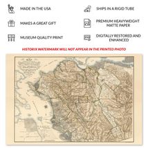
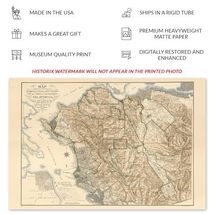
Bullet point: VINTAGE MAP REPRODUCTION: You?ll love this high quality historic reproduction of 1894 Alameda Contra Costa Map Print. Our museum quality prints are archival grade, which means it will look great and last without fading for over 100 years. Our print to order maps are made in the USA and each map is inspected for quality. This beautiful artwork is a perfect addition to your themed decor. Vintage maps look great in the home, study or office. They make a perfect gift as well.
Product description:
Alameda and Contra Costa Counties have been essential areas in California's Northern Coast for centuries as the regions developed with bustling ports. This map was produced in a period of significant growth and prosperity, which the region had enjoyed since the middle of the nineteenth century when vast gold reserves were discovered in the Sierra Nevada Mountains, bringing considerable wealth to the cities as a banking hub on the West Coast. During the nineteenth century, San Francisco rivaled Los Angeles, Seattle, and Portland, Oregon, as a trading port for goods being imported to the United States from Asia and exporting American-made goods to foreign markets.
As the nation approached the turn of the century, the Bay Area, along with the rest of the country, was being transformed in the years of the Industrial Revolution and a period of peace following the conclusion of the American Civil War in addition to technological advances in transportation, architecture, and culture as America became one of the most influential nations in the world and continued to develop. This map was produced by the prolific San Francisco-based lithography firm Britton Rey, who created numerous works during the nineteenth century.
This map's distinctive style and classic aesthetic immediately transport the viewer back in time, creating a lasting bond between the past and present that illustrates the evolution and growth of the region through the following centuries. This is an authentic piece of cartographical history.
Added to your wish list!
- HISTORIX Vintage 1894 Alameda & Contra Costa Map Print - 24x36 Inch Old Map of A
- 8 in stock
- Handling time 1 day.
- Returns/refunds accepted
Get an item reminder
We'll email you a link to your item now and follow up with a single reminder (if you'd like one). That's it! No spam, no hassle.
Already have an account?
Log in and add this item to your wish list.