Rendered at 14:08:43 12/04/25

Sign up and get $15.00 bCredits free to use at checkout and another $5.00 bCredits when you make your first purchase. More info
Envío gratis
46 recent views
National Geographic April 1982 Map/Poster - The Face & Faith of Poland
$60.23 MXN
(It may be possible to pay only $2.80 instead of $3.30 when you
use your bCredits at checkout)
Sign up and get $15.00 bCredits free to use at checkout and another $5.00 bCredits when you make your first purchase. More info
Los buques de
United States

Share & earn! Sign in, share this or any listing, and you’ll get commission when it sells.
Learn more
Las opciones de envío
No hay precio de envío se especifica en MX
Los buques de
United States
Política de oferta
OBO - El vendedor acepta ofertas en este artículo.
Detalles
La política de devoluciones
Protección de compra
Opciones de pago
PayPal accepted
PayPal Credit accepted
Venmo accepted
PayPal, MasterCard, Visa, Discover, and American Express accepted
Maestro accepted
Amazon Pay accepted
Nuvei accepted
Rasgos del artículo
| Categoría: | |
|---|---|
| cantidad disponible: |
Sólo uno en stock, para muy pronto |
| Condition: |
New |
| Country: |
Poland |
| Publication Date: |
1982 |
Detalles del anuncio
| Envío de descuento: |
Vendedor paga el envío para este artículo. |
|---|---|
| Publicado en venta: |
Más de una semana |
| Artículo número: |
1565574059 |
Descripción del Artículo
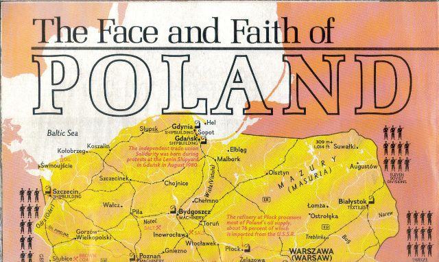
National Geographic April 1982 Map/Poster - The Face Faith of Poland
folded size: 9.3 x 5.7 inches
Poland covers an administrative area of 120,743 sq mi, and is the ninth-largest country in Europe.
Approximately 120,423 sq mi of the country's territory consists of land, 788 sq mi comprises
internal waters and 3,391 sq mi is territorial sea. Topographically, the landscape of Poland is characterised by
diverse landforms, water bodies and ecosystems. The central and northern region bordering the Baltic Sea lie
within the flat Central European Plain, but its south is hilly and mountainous. The average elevation above the
sea level is estimated at 173 metres.
The country has a coastline spanning 480 mi; extending from the shores of the Baltic Sea, along the
Bay of Pomerania in the west to the Gulf of Gdansk in the east. The beach coastline is abundant in sand dune
fields or coastal ridges and is indented by spits and lagoons, notably the Hel Peninsula and the Vistula Lagoon,
which is shared with Russia. The largest Polish island on the Baltic Sea is Wolin, located within
Wolin National Park. Poland also shares the Szczecin Lagoon and the Usedom island with Germany.
The mountainous belt in the extreme south of Poland is divided into two major mountain ranges; the Sudetes in
the west and the Carpathians in the east. The highest part of the Carpathian massif are the Tatra Mountains,
extending along Poland's southern border. Poland's highest point is Mount Rysy at 8,205 ft in elevation, located
in the Tatras. The highest summit of the Sudetes massif is Mount Sniezka at 5,260 ft, shared with the
Czech Republic. The lowest point in Poland is situated at Raczki Elblaskie in the Vistula Delta, which is 5.9 ft
below sea level.
Poland's longest rivers are the Vistula, the Oder, the Warta, and the Bug. The country also possesses one of the
highest densities of lakes in the world, numbering around ten thousand and mostly concentrated in the
north-eastern region of Masuria, within the Masurian Lake District. The largest lakes, covering more than
39 sq mi, are Sniardwy and Mamry, and the deepest is Lake Hancza at 356 ft in depth.
Very Good condition
Added to your wish list!
- National Geographic April 1982 Map/Poster - The Face & Faith of Poland
- 1 in stock
- Price negotiable
Get an item reminder
We'll email you a link to your item now and follow up with a single reminder (if you'd like one). That's it! No spam, no hassle.
Already have an account?
Log in and add this item to your wish list.