Rendered at 05:13:56 05/22/25
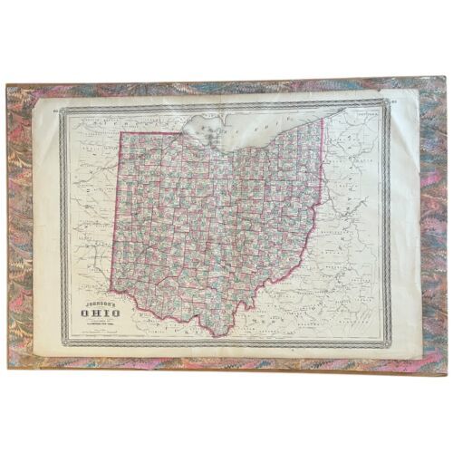
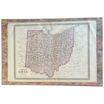


State Of Ohio Original 1864 Copper-Plate Map by A. J. Johnson Antique Civil War
Los buques de
United States


Las opciones de envío
Los buques de 1 business day Detalles
No hay precio de envío se especifica en MX
Los buques de
United States
Política de oferta
OBO - El vendedor acepta ofertas en este artículo.
Detalles
La política de devoluciones
Full refund available within 30 days
Protección de compra
Opciones de pago
PayPal accepted
PayPal Credit accepted
Venmo accepted
PayPal, MasterCard, Visa, Discover, and American Express accepted
Maestro accepted
Amazon Pay accepted
Nuvei accepted
Rasgos del artículo
| Categoría: | |
|---|---|
| cantidad disponible: |
Sólo uno en stock, para muy pronto |
| Condition: |
Used |
| Type: |
Anthropomorphic Map |
| Maker: |
A. J. Johnson |
| Original/Reproduction: |
Antique Original |
| Date Range: |
1800-1899 |
| Year: |
1864 |
| Country/Region: |
United States of America |
| US State: |
Ohio |
| Cartographer/Publisher: |
Alvin Jewett Johnson |
| Format: |
Atlas Map |
| Printing Technique: |
Copper Plate |
| North America States & Provinces: |
Ohio |
| Publication Year: |
1864 |
| Original Reproduction Reprint: |
Original |
Detalles del anuncio
| Las políticas del vendedor: | |
|---|---|
| Envío de descuento: |
Pesos de envío de todos los elementos se suman para el ahorro. | Envío gratis para pedidos superiores a $300.00 |
| Precio de descuento: |
10% De descuento w / $200.00 pasó |
| Publicado en venta: |
Más de una semana |
| Artículo número: |
1724892097 |
Descripción del Artículo
Rare and very beautiful genuine antique hand colored map of the above region and year from the extremely rare Johnson
Atlas. AJ Johnson was one of the pre-eminent American map publishers in
the mid-19th Century.
Publisher/Cartographer: A. J. Johnson published maps from 1860 to the
late 1880s. He began his publishing empire with the purchase of J. H.
Coltonae(tm)s map plates in 1860. Johnson transferred the original
Colton steel plate engravings to cheaper lithographic stones, allowing
his firm to produce more maps at a lower price point. The next three
years would see Johnson rise to become the most prominent American map
publisher of his period. At the outbreak of the Civil War, Johnson transitioned his publishing firm from Virginia to New York , and continued to produce maps and atlases into the 1880s. Johnson maps are
known for their size, accuracy, detail, and stunning, vivid hand coloring.
Pre-owned, pretty good condition with some light browning to paper and some slight losses and wear around the edges. Appears to be lightly adhered to the marbled paper and then than paper lightly adhered to the stiff backing. We can either ship flat or removed the stiff backing and ship rolled with the marbled paper.
Overall dimensions as shown about 20 x 30".Page numbers 62 and 63 appear at the upper corners, appears pulled from an oversize atlas. Dimensions of the double sheet as shown measure about 26-1/4" by 18-1/4".
Item Location: Back Warehouse, Right, Large Paper Bin.
Added to your wish list!

- State Of Ohio Original 1864 Copper-Plate Map by A. J. Johnson Antique Civil War
- 1 in stock
- Price negotiable
- Handling time 1 day.
- Returns/refunds accepted
Get an item reminder
We'll email you a link to your item now and follow up with a single reminder (if you'd like one). That's it! No spam, no hassle.
Already have an account?
Log in and add this item to your wish list.