Rendered at 20:39:36 05/21/25


Vintage 60’s USGS Topo Map Blackcap Mountain Maxon Dome Fresno CA Original Chart
Los buques de
United States

Las opciones de envío
Los buques de 2 business days Detalles
No hay precio de envío se especifica en MX
Los buques de
United States
La política de devoluciones
None: All purchases final
Protección de compra
Opciones de pago
PayPal accepted
PayPal Credit accepted
Venmo accepted
PayPal, MasterCard, Visa, Discover, and American Express accepted
Maestro accepted
Amazon Pay accepted
Nuvei accepted
Rasgos del artículo
| Categoría: | |
|---|---|
| cantidad disponible: |
Sólo uno en stock, para muy pronto |
| Condition: |
Unspecified by seller, may be new. |
| Type: |
Anthropomorphic Map |
| Maker: |
USGS |
| Original/Reproduction: |
Antique Original |
| Date Range: |
1960-1969 |
| Year: |
1953 |
| Country/Region: |
United States of America |
| US State: |
California |
| Mexican State: |
Nayarit |
| Format: |
Sheet Map |
| Printing Technique: |
Lithography |
| Cartographer/Publisher: |
Geological Survey Control |
| Feature Refinement: |
True Vintage Map |
| City: |
Black Cap Mountain |
| Publication Year: |
1962 |
| Canadian Province: |
N/A |
| Topic: |
Maps |
| Original Reproduction Reprint: |
Original |
Detalles del anuncio
| Las políticas del vendedor: | |
|---|---|
| Envío de descuento: |
Pesos de envío de todos los elementos se suman para el ahorro. |
| Publicado en venta: |
May 13 |
| Artículo número: |
1746847645 |
Descripción del Artículo
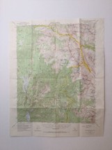
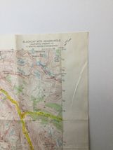
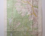
Blackcap Mtn. Quadrangle California-Fresno Co 15 Minute Series Topographic. Maxon Dome, Lost Canyon 1962 Vtg USGS Original Topo Chart Map. Marked N3700-W11845/15. Minor corrections made 1962 AMS 2258 III Series V795. Overall good condition, some yellowing, marks, and creases. Some staining on the backside of the map and top front of the map, shown in the photos. Map has been folded. No holes. Blackcap Mtn. 1,5 Calif. written in marker on the backside. Does not bleed through. Map measures approximately 21" tall x 17" wide. Printed area measures approximately 17.5" tall x 14" wide. Map will be delivered folded, as shown in the photo.
Added to your wish list!
- Vintage 60’s USGS Topo Map Blackcap Mountain Maxon Dome Fresno CA Original Chart
- 1 in stock
- Handling time 2 day.
Get an item reminder
We'll email you a link to your item now and follow up with a single reminder (if you'd like one). That's it! No spam, no hassle.
Already have an account?
Log in and add this item to your wish list.