Rendered at 16:13:07 05/20/25


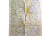
Vintage Local Aeronautical Chart Map of Boston 1966 29" X 22"
$583.74 MXN
Los buques de
United States

Las opciones de envío
Política de oferta
OBO - El vendedor acepta ofertas en este artículo.
Detalles
La política de devoluciones
None: All purchases final
Protección de compra
Opciones de pago
PayPal accepted
PayPal Credit accepted
Venmo accepted
PayPal, MasterCard, Visa, Discover, and American Express accepted
Maestro accepted
Amazon Pay accepted
Nuvei accepted
Rasgos del artículo
| Categoría: | |
|---|---|
| cantidad disponible: |
Sólo uno en stock, para muy pronto |
| Condition: |
Used |
| Country/Region of Manufacture: |
United States |
| Modified Item: |
No |
| Type: |
Maps |
Detalles del anuncio
| Envío de descuento: |
No ofrece el envío combinado |
|---|---|
| Publicado en venta: |
Más de una semana |
| Artículo número: |
1737969546 |
Descripción del Artículo
Vintage Local Aeronautical Chart featuring Boston showing FAA and Military training areas. The map feature elevations, national parks and relevant airports. The map was produced by the US department of Commerce. The scale is 1:250.000 and is shipped with USPS First Class Package.
Added to your wish list!
- Vintage Local Aeronautical Chart Map of Boston 1966 29" X 22"
- 1 in stock
- Price negotiable
- Handling time 2 day. Estimated delivery: Thu, Jun 12th
Get an item reminder
We'll email you a link to your item now and follow up with a single reminder (if you'd like one). That's it! No spam, no hassle.
Already have an account?
Log in and add this item to your wish list.