HISTORIX Vintage 1618 Paris France Map and 50 similar items


Envío gratis
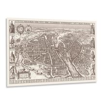
HISTORIX Vintage 1618 Paris France Map Poster - Vintage Bird's Eye View Map of P
$774.84 MXN - $1,162.36 MXN
View full item details »

Las opciones de envío
Los buques de 1 business day Detalles
No hay precio de envío se especifica en MX
Los buques de
United States

La política de devoluciones
Full refund available for DOAs
Detalles
Protección de compra
Opciones de pago
PayPal accepted
PayPal Credit accepted
Venmo accepted
PayPal, MasterCard, Visa, Discover, and American Express accepted
Maestro accepted
Amazon Pay accepted
Nuvei accepted
View full item details »
Las opciones de envío
Los buques de 1 business day Detalles
No hay precio de envío se especifica en MX
Los buques de
United States
La política de devoluciones
Full refund available for DOAs
Detalles
Protección de compra
Opciones de pago
PayPal accepted
PayPal Credit accepted
Venmo accepted
PayPal, MasterCard, Visa, Discover, and American Express accepted
Maestro accepted
Amazon Pay accepted
Nuvei accepted
Rasgos del artículo
| Categoría: | |
|---|---|
| cantidad disponible: |
16 En stock |
| Condition: |
New |
| ASIN: |
B0DM4GC2VN |
| color: |
Natural |
| manufacturer: |
HISTORIX |
| Bullet Point: | |
| Product Description: | |
| Brand: |
HISTORIX |
| Item Name: | |
| Item Type Keyword: |
wall-maps |
| Product Site Launch Date: |
2024-11-06T08:17:47.705Z |
| sizes: |
Detalles del anuncio
| Las políticas del vendedor: | |
|---|---|
| Envío de descuento: |
Vendedor paga el envío para este artículo. |
| Publicado en venta: |
May 1 |
| Artículo número: |
1743625290 |
Descripción del Artículo
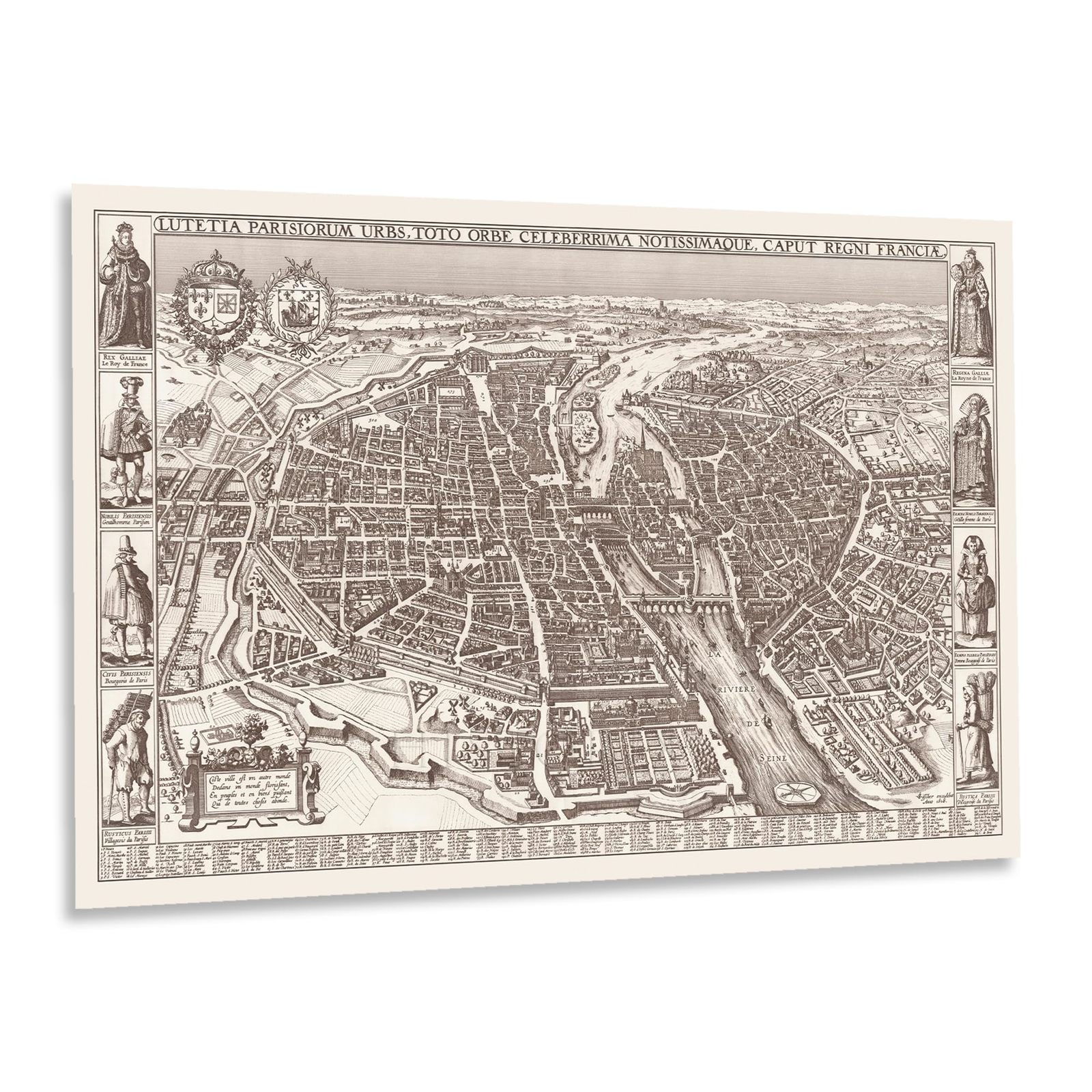
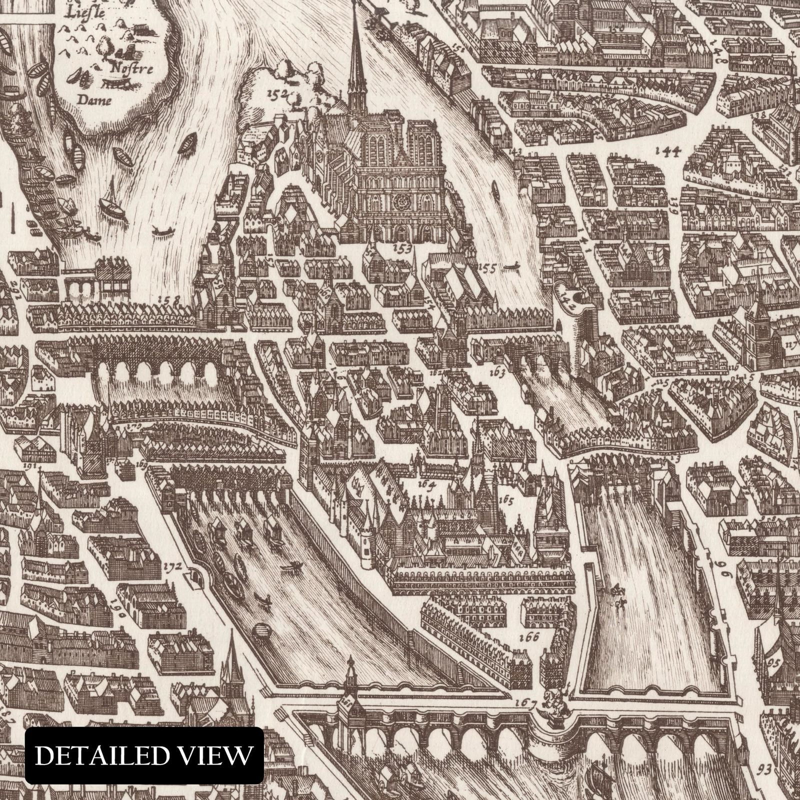
One of the earliest examples of a panoramic, or birds-eye perspective, style of map, this illustration of Paris bears a distinctive style and unique aesthetic that offers the viewer a period of significant transformation into one of Europe's most iconic and excellent cities, whose influence on the worlds of philosophy, literature, art, music, and culture at large cannot be underestimated since its earliest days following its formation during the third century BC. The city's location on the banks of the River Seine has long made it an important trading hub, and the river has become synonymous with some of the city's most iconic images, which are revered for its architecture and design.
This map, produced in 1615, remains one of the most enduring examples of not only the city itself but also early cartography. Cartography was made for purposes other than navigation and relied on featuring prominent people, places, and buildings, including churches and civic features. The Romans captured the city in 52 BC, becoming a hub of trade and economic prosperity, which sparked the construction of a forum, numerous baths, temples, theaters, and an amphitheater.
Christianity was introduced to Paris in the third century AD by Saint-Denis, the First Bishop of Paris, who, according to legend, was beheaded for refusing to renounce his faith to Roman occupiers and walked headless before reaching his burial spot, which is now the Basilica of Saint-Denis where French Kings were also interred after death.
Additional Details
------------------------------
Bullet point: VINTAGE MAP REPRODUCTION: You?ll love this high quality historic reproduction of 1618 Paris France Map Poster. Our museum quality prints are archival grade, which means it will look great and last without fading for over 100 years. Our print to order maps are made in the USA and each map is inspected for quality. This beautiful artwork is a perfect addition to your themed decor. Vintage maps look great in the home, study or office. They make a perfect gift as well.
Product description:
One of the earliest examples of a panoramic, or birds-eye perspective, style of map, this illustration of Paris bears a distinctive style and unique aesthetic that offers the viewer a period of significant transformation into one of Europe's most iconic and excellent cities, whose influence on the worlds of philosophy, literature, art, music, and culture at large cannot be underestimated since its earliest days following its formation during the third century BC. The city's location on the banks of the River Seine has long made it an important trading hub, and the river has become synonymous with some of the city's most iconic images, which are revered for its architecture and design.
This map, produced in 1615, remains one of the most enduring examples of not only the city itself but also early cartography. Cartography was made for purposes other than navigation and relied on featuring prominent people, places, and buildings, including churches and civic features. The Romans captured the city in 52 BC, becoming a hub of trade and economic prosperity, which sparked the construction of a forum, numerous baths, temples, theaters, and an amphitheater.
Christianity was introduced to Paris in the third century AD by Saint-Denis, the First Bishop of Paris, who, according to legend, was beheaded for refusing to renounce his faith to Roman occupiers and walked headless before reaching his burial spot, which is now the Basilica of Saint-Denis where French Kings were also interred after death.
|
Why are we showing these items?
Booth
Historic Prints |

|


-
Refine your browsing experience
We can show you more items that are exactly like the original item, or we can show you items that are similar in spirit. By default we show you a mix.


Este artículo ha sido añadido a su carrito
 HISTORIX Vintage 1618 Paris France Map Poster - Vintage Bird's Eye View Map of P added to cart.
16 Disponible en stock
HISTORIX Vintage 1618 Paris France Map Poster - Vintage Bird's Eye View Map of P added to cart.
16 Disponible en stock
Ver el carro o seguir comprando.
 Por favor, espere mientras termine de agregar este artículo a su carrito.
Get an item reminder
We'll email you a link to your item now and follow up with a single reminder (if you'd like one). That's it! No spam, no hassle.
Already have an account?
Log in and add this item to your wish list.